Summary
- Hurricane hunters collect data by flying into the eye of the storm and circling back, collecting data around the perimeter of the storm.
- The data collected by hurricane hunters, such as pressure, temperature, humidity, and wind speed, helps forecasters accurately predict the behavior and severity of hurricanes, ensuring the safety of local residents.
When Hurricane Laura hit the Texan coast in 2020, the US Government sent planes into the eye of the storm to gather weather data. The more data the planes send back, the better experts can predict intensity levels.
Hurricane hunters collect data from the eye of the storm
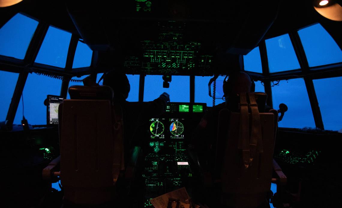
The United States Air Force has specialist crews that fly into hurricanes. They are called hurricane hunters.
We generally fly into the eye, then out and then circle back and do it again, Major Devon Meistr of U.S. Air Force Reserves Hurricane Hunter Squadron told UNCTV Science.
We fly a triangle pattern back and forth through the storm. So what we are doing is collecting data around the perimeter of the storm.
Major Devon's counterparts at the National Oceanic and Atmospheric Administration also fly into hurricanes. They've just posted a clip of a flight into inside the eye of Hurricane Laura.
Flights into hurricanes began in the 1940s
Crazy brave pilots have been flying into hurricanes since the 1940s. The first flight wasn't about science or weather. Instead, a couple of RAF airmen stationed at Byran Air Force Base wanted to show up their USAF counterparts who were busy worrying about their planes getting wet. That first flight, into the eye of Hurricane Surprise in 1943, returned safely and forged the way for future flights.
Today, the United States Government runs fleets of hurricane hunter aircraft via the Air Force Reserve 53rd Weather Reconnaissance Squadron and the civilian National Oceanic and Atmospheric Administration (NOAA).
The USAF squadron is based at Keesler Air Force Base in Biloxi, Mississippi. The squadron operates ten Lockheed WC-130J aircraft that conduct mostly low-level flights into hurricanes. The NOAA hurricane hunters are based at Lakeland Linder International Airport in Lakeland, Florida. They fly two Lockheed WP-3D Orion aircraft and a G-IV Gulfstream high-altitude jet. That NOAA Twitter post came from an Orion aircraft yesterday.

The Orions take atmospheric and radar measurements. The Gulfstream flies above 41,000 feet to record upper and lower-level winds that affect hurricane movements.
Data collected helps predict a hurricane's behaviour
The USAF hurricane flights typically last about 11 hours. Multiple recordings get made to assess what the hurricane is doing. A standard task involves a sonde, or a drop sonde. It's like a weather ballon that goes up, except a sonde goes down. The sonde falls through the weather at 2,500 feet per minute. On the way down, it measures pressure, temperature, humidity, and wind speed multiple times a second.
"We get a nice vertical picture of the atmosphere from the latitude of the aircraft to the surface of the ocean, and that data is relayed via radio in this device back to the airplane," Lt. Col. Drew Clark, a navigator on the Hurricane Hunter planes, told UNCTV Science.
This data, along with any visual observations, goes straight to weather stations and meteorologists. It helps forecasters accurately predict what the hurricane is doing, where it is heading, and how severe it will be. As Hurricane Laura hits Texas today's, that's information local residents will be relying on to stay safe.
Get the latest aviation news straight to your inbox: Sign up for our newsletters today.
Hurricane Hunters in action
Just this past week, the Hurricane Hunters departed Keesler Air Force Base in Mississippi to fly weather reconnaissance missions into Hurricane Hilary. This comes as there is a growing concern that Hurricane Hilary will dump a year’s worth of rain in California, Nevada, and Arizona. In fact, the fiver every tropical storm watch for California has been issued as the storm has reached category 4 status today, by the National Hurricane Center (NHC).
On August 18th, the 53rd Weather Reconnaissance Squadron and maintenance personnel flew their first mission into the storms from Santa Maria Public Airport in Southern California. While satellites provide information pertaining to the storm, they do not provide information about what is happening inside the storm. To assist the NHC, Hurricane Hunters fly through the storm at an altitude of 10,000 feet up to six times to collect real-time data about Hurricane Hilary.
Lieutenant Colonel Steve Burton, mission commander for 53rd WRS for the weather deployment, commented:
“The data we collect can improve a forecast by anywhere from 15-25 percent.”
During the mission, the aircraft will collect real-time weather data, including surface pressure, temperature, humidity, wind speed, and direction. Furthermore, during each pass through the storm, the aircraft will release dropsondes at different points in the storm, which further collects weather data during its descent into the ocean.